
Aerial Data & AI Analytics
From drone imagery to measurements, maps, and decisions
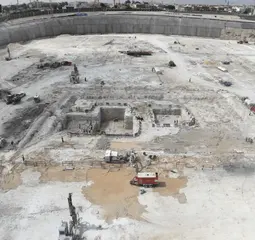
A single drone flight produces thousands of images — but the value isn't the imagery, it's what you extract from it. We turn raw aerial data into measurable outputs: accurate survey maps, 3D models, volume and quantity calculations, and progress indicators presented in clear dashboards.
Our team combines survey-grade flight operations, civil engineering, and data analysis — so the outputs are both geometrically sound and practically useful for project decisions, not just pretty pictures.
Use cases
Volume & quantity calculation
Measuring stockpiles, cut and fill from aerial models instead of manual survey.
Project progress tracking
Comparing as-built reality to plans through recurring surveys and clear indicators.
Orthomosaics & 3D models
Accurate orthomosaic maps and 3D models of sites and structures.
Executive dashboards
Turning site data into a single dashboard a decision-maker understands in minutes.
How we work
- 1
Define required outputs
We start from the decision you need — quantities? progress? documentation? — and design the mission around it.
- 2
Flight planning & capture
Survey-grade flight paths that guarantee the coverage and accuracy required.
- 3
Processing & analysis
Photogrammetric processing followed by AI analysis to extract measurements and indicators.
- 4
Delivery & recurring cadence
You receive maps, reports, and dashboards, with recurring surveys scheduled to track change.
What you receive
- Orthomosaic maps and 3D models
- Documented quantity and measurement reports
- A project-indicator dashboard
- A time-stamped archive of site evolution
Common questions
How accurate are aerial measurements?
With proper survey planning and ground control points, accuracy reaches levels suitable for quantity calculations and construction tracking; we agree the target accuracy with you before flying.
How often should a site be surveyed?
For active construction sites, typically monthly or biweekly; we recommend a cadence based on how fast the site changes and how the data feeds your decisions.
Can you analyze drone data we captured ourselves?
Yes — we process and analyze your existing data, and if its quality isn't sufficient we'll tell you honestly and propose a re-capture.
Related services
Ready to see what others miss?
Tell us about your project and we'll show you how AI and aerial technology can help.
Start a Conversation